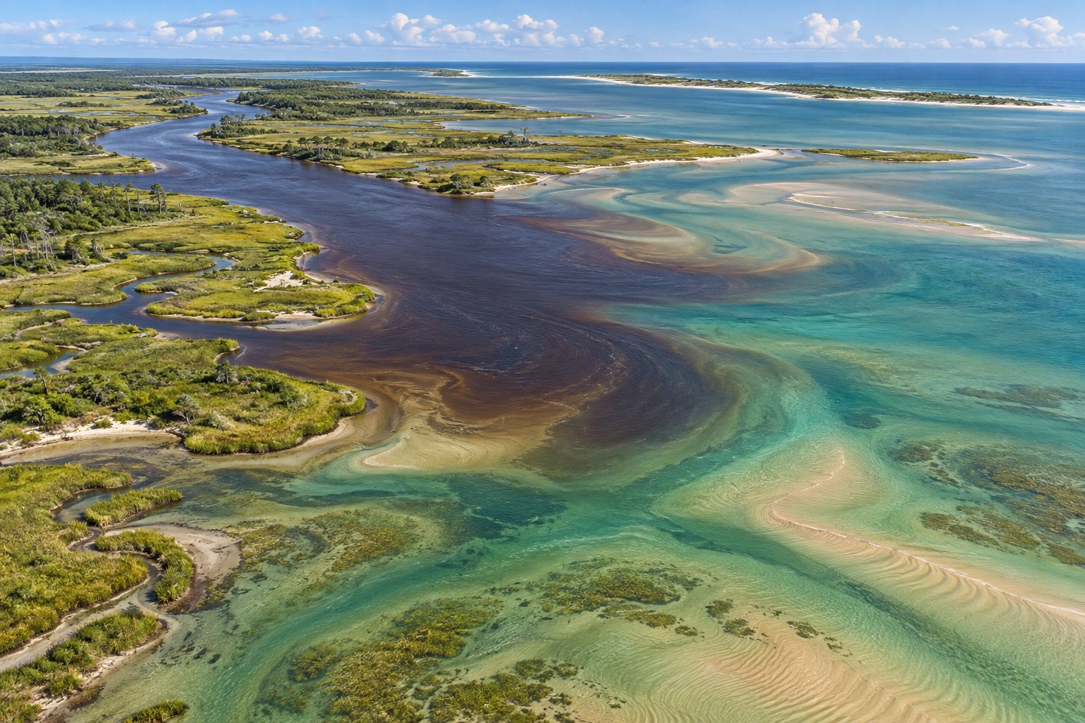
Start by understanding the water coming downstream
Apalachicola is a river town beside a broad, shallow bay. Fresh water, salt water, marsh drains and oyster habitat meet here. The most useful fishing question is often not how far to travel, but which kind of water your target fish is using today.
Rain far upstream can matter even when the sky over town is clear. River flow, local rain, wind and tides all affect the amount of salt in the bay. Water color can change too. A brown tint is not proof that fishing is poor, and clear water is not a promise of a catch.
Think of the area as connected pieces. The lower river carries fresh water and floating material. The bay has changing mixtures of fresh and salt water. St. George Island separates much of the bay from the open Gulf. Cuts and passes move water between them.
STAY IN TOWN
Try a public pier
Lafayette Park offers a shore-based starting point on the bay.
The city lists a long fishing pier at Lafayette Park on Avenue B. The park also has picnic tables, a gazebo and play equipment. It is a practical place to consider when you want a short outing without launching a boat.
Begin with a modest bait and a rig you can control from the platform. Try a small shrimp near the bottom, then adjust the depth if the bait disappears into weed or soft sediment. Fish may be using a lane beside the pier rather than sitting directly beneath its end.
Before carrying a cooler down, confirm the pier is open. Waterfront structures can need repairs after storms. Keep the walkway clear and leave the rail available to people who are simply enjoying the view.
RIVER AND BAY ACCESS · BOAT RAMP
Battery Park Marina
Battery Park is beneath the John Gorrie Bridge. Its public ramp provides a starting point for the river and bay. Prepare your boat away from the ramp, then use the launch lane efficiently.
The city requires a launch pass or the appropriate resident decal. Visitors should check the current daily payment instructions before arriving. A place to launch is not a promise that every nearby dock is available for bank fishing.
Look at the wind forecast before committing to a route across the bay. A short-looking line on a map can become an uncomfortable crossing in a small boat. Choose a return route with enough water under the hull as the tide changes.
WORKING RIVERFRONT
Riverfront Park and Scipio Creek
The town’s riverfront and Scipio Creek show why fishing and seafood remain part of Apalachicola’s identity. The city identifies Scipio Creek Boat Basin as a commercial fishing marina. That means work boats, lines, equipment and vehicle access need room.
Use these places to learn the setting, not as automatic permission to fish from every dock. Ask about public access before setting tackle on a working platform. Do not walk onto a boat or handle equipment to clear a casting lane.
From a permitted position, notice which direction floating material moves. Watch for small baitfish near the edge of the flow. If you cannot fish safely without interfering with operations, choose the public park option instead.
A shaded waterfront view in Apalachicola. Photograph by Martin Haeusler, 2011. Photo credit and license.
ACROSS THE BAY
St. George Island adds a different kind of fishing
Apalachicola’s bayfront is not an open Gulf beach. If you want to fish rolling surf from sand, plan a separate drive to St. George Island. The state park at the eastern end of the island has undeveloped shoreline and fishing opportunities.
Confirm the park’s current access arrangements, entry hours and any closures. Public access to one part of the island does not give you access through private property elsewhere. A distant point that looks easy on a map may involve more walking or restricted access than expected.
On the Gulf side
Search for a deeper strip between the beach and a sandbar. A small bottom bait can reach feeding fish without a heroic cast. Use shrimp for a broad first test and consider sand fleas when you are aiming for pompano.
Keep track of the sideways movement of your line. If surf pushes the rig toward swimmers or other anglers, it is time to change position or stop. Use a sinker your rod can cast safely.
On the bay side
The focus shifts to shoreline edges, vegetation and nearby channels. A float can suspend a shrimp above the bottom. A lightly weighted lure lets you explore openings without constantly dragging through plants.
The bay side may look calmer than the Gulf, but wind across open bay water still matters. For paddling, judge the return leg before drifting or traveling away from your launch.
READ THE ESTUARY
Look for a useful boundary, not a perfect water color
A boundary is simply where one condition changes into another. It might be the edge of a muddy plume, shallow sand beside a channel, or marsh grass beside open water. Fish can use these changes because food passes through them.
After rain, do not race across the bay looking only for blue water. First ask whether your target can use the water around you. Look for living bait, feeding movement and a safe place to present a hook.
River water and bay water meet along changing edges. This habitat illustration is not a chart of Apalachicola Bay.
At a marsh drain
Water leaving the grass can carry small shrimp and fish. Place a bait where it can pass the mouth of the drain without snagging. Keep the boat outside the small feeding area so you do not disturb it.
When the water level drops, the useful depth may shift farther from the grass. Follow the edge gradually rather than staying fixed on the spot that worked earlier.
Beside oyster habitat
Oyster shells make hard, uneven cover in an otherwise soft setting. Small animals use the gaps. Fish can feed along the outer edge without sitting on top of the shallowest shell.
Keep enough clearance for the hull and motor. Do not drag an anchor or propeller across a bar. Shell can cut both line and feet.
Make a small observation record
Write down the launch time, wind direction, water appearance and where the bites came from. Add whether the water was rising or falling at your position. Over several visits, that record becomes more useful than a claim that one named spot always produces.
A tide prediction is a planning tool. It does not show every river-driven current or wind effect inside the estuary. Confirm the pattern with your eyes once you arrive.
FISH TO BUILD A TRIP AROUND
Let feeding style guide the bait
Redfish along marsh and shell edges
Redfish are a good reason to study the edge of a marsh rather than casting only toward the center of the bay. Shrimp, small baitfish and crabs fit their broad diet. A soft lure can help you cover a shoreline where the bottom is clear enough to retrieve it.
Cast ahead of a fish or into the route where you expect food to travel. If the line lies across sharp shell, reposition before a strong fish pulls it tight. A little abrasion can become a break very quickly.
Do not crowd a school into shallow water. Give it space and use an angle that lets your offering reach the fish naturally.
Spotted seatrout near grass and deeper edges
A shrimp beneath a float is useful where bottom vegetation would hide the bait. Set the depth for the actual water beneath you. A rig that worked on a deeper bank may hang in the grass on a shallow flat.
With a small soft lure, try a steady swimming retrieve first. If it repeatedly returns covered in grass, reduce the weight or work the open edge. When the water cools, spend more time on nearby depth changes.
Handle trout gently. Their soft mouth and delicate body are reasons to use suitable tackle and a quick, careful release.
Black drum around bottom food
Black drum feed on bottom animals, so a small crab or shrimp bait can be a sensible choice around suitable shell and structure. Keep the bait close enough to the bottom to be found, but not buried beneath it.
Use a hook that matches the bait rather than one chosen only for the largest possible fish. Check that the point is exposed. When fishing a circle hook, allow steady pressure to develop instead of making a violent strike.
Flounder on sand beside moving water
Flounder wait near the bottom and take food passing within reach. Work a small baitfish or soft lure across a sandy lane beside a depth change. Move slowly enough to stay in that lower layer.
A fast retrieve well above the bottom may miss the reason you chose that spot. If you cannot feel or judge the depth, change the weight in small steps. Confirm harvest rules separately from the seasonal chance of finding fish.
Sheepshead near hard surfaces
Try a small crustacean bait beside accessible structure. These fish can remove bait with subtle taps. Keep the offering close enough to feel a change, while avoiding a position that catches the hook in every crevice.
Choose a safe landing position before dropping the rig. Sharp shells, wet wood and fish spines all deserve attention when the fish comes close.
Beach fish and Gulf visitors
On St. George Island, a beach plan may include whiting, pompano or redfish. Farther toward open Gulf water, bait schools can attract Spanish mackerel and other moving fish. These are different outings from a quiet town-pier session.
A boat trip beyond the bay needs marine-weather planning, suitable equipment and knowledge of the route. Do not treat a short distance from land as proof that the trip is easy.
A BAIT PLAN FOR THIS BAY
Choose how the bait should travel
Your fishing position
First offering
How to present it
Open edge beside marsh grass
Live shrimp below a float
Let it pass the edge without burying in vegetation.
Sandy patch with light current
Small baitfish or soft lure
Keep it near the bottom and move it through the patch with control.
Legal pier beside deeper water
A compact shrimp bait
Try the near edge before casting far beyond it.
Accessible shell or pilings
Small crab bait
Hold it beside the cover and lift before it wedges into a gap.
Island surf with room to fish
Shrimp or sand flea
Use a bottom rig that stays in the chosen lane.
Keep bait cool and protected from drying wind. Replace a soft, damaged bait that no longer stays on the hook. If the hook keeps coming back clean, shorten the time between checks before assuming that bigger bait will help.
What to carry for inshore fishing
A medium spinning outfit, several small jig heads, a few floats and spare leader material cover many starting methods. Bring a measuring tool and long-nose pliers. Choose line and leader strength for the size of fish, rough cover and current you expect.
A light setup is pleasant to cast, but it should still let you land a fish without a long, exhausting fight. If you intend to fish heavy structure, ask a local tackle shop to match the outfit to that job.
SEASONAL DECISIONS
Water conditions can outweigh the month
Early-year fronts
Choose protected routes and investigate depth beside the shallows. A slower bait presentation can be useful when the water is cold. Plan around the wind that follows a front, not just the temperature shown for town.
Spring warming
Explore the bay’s feeding edges as activity changes. An island beach session offers another option when surf is manageable. Keep an eye on river conditions after heavy rain upstream.
Hot-weather mornings
Use the cooler part of the day for a short route. Carry drinking water and have a storm exit that does not depend on a long exposed crossing. Bait can deteriorate quickly in a hot boat.
Autumn changes
Look for small fish moving along banks and channels. Changing temperatures can shift a pattern between visits. Check the next front before planning a full day on open bay water.
The bay does not follow a simple clear-water or muddy-water rule. Keep comparing the actual signs of feeding rather than deciding the whole trip from one look at the water beside the ramp.
THREE REALISTIC OUTINGS
Match the plan to the time you have
A town visit with a rod
Check Lafayette Park pier access. Carry one outfit, a small bait supply and a drink. Spend the first few minutes watching water movement. Fish a short session and leave the park tidy.
A cautious bay loop
Arrange the Battery Park launch pass, then choose a route that stays within your boat’s limits. Try one marsh edge and one nearby depth change. Keep the return crossing in mind as wind rises.
An island beach morning
Check St. George Island park access and surf. Pack for sand rather than a boat. Test the closest trough, move if swimmers arrive and allow enough time to walk back before leaving the park.
A BAY WITH WORK TO DO
Protect the habitat and respect the waterfront
Apalachicola’s oyster habitat is both a natural resource and part of a working economy. Fishing near shell does not authorize taking oysters. Shellfish harvesting has its own rules and area restrictions.
Give commercial boats space at launches and docks. Keep hooks away from ropes, nets and working equipment. If someone needs the ramp for a launch, move your tackle rather than treating the lane as a fishing platform.
Check current rules before keeping any fish. Regional boundaries, species limits and seasonal closures can change what is allowed on the same stretch of water.
Support a fish’s body during release and avoid dropping it on a deck. Take all bait packaging and fishing line back to shore. On shallow flats, slow down before the hull or motor touches the bottom.
APALACHICOLA, EXPLAINED
Questions worth settling before you leave
Is there a Gulf beach in downtown Apalachicola?
The town faces the river and bay. St. George Island provides the nearby barrier-island beach outing. Plan for the extra drive and the access rules at your chosen entrance.
Does brown water mean there are no fish?
No. River flow and natural material can color the water. Look for bait, current edges and the habitat your target uses. Water appearance is one clue, not a complete fishing report.
Can visitors launch at Battery Park?
The city provides public ramp access with launch-pass requirements. Check the visitor payment process and current fees before bringing a trailer.
Can I fish from any shrimp-boat dock?
No. Working docks and private property need permission. Public parks and designated fishing access are better starting points for a visitor.
Should I put a shrimp directly on the grass?
It can become hidden or tangled. A float lets you suspend it above the vegetation. Set the depth for the water at that location.
Can I collect oysters while I am fishing?
Do not assume so. Oyster harvesting is separately regulated, and the allowed area or season may differ from finfish rules. Confirm the current requirements first.
What makes a kayak route difficult here?
Open bay crossings, changing wind, shallow routes and moving water can all complicate a return. Pick a short route that suits your ability and avoid depending on a distant landing.