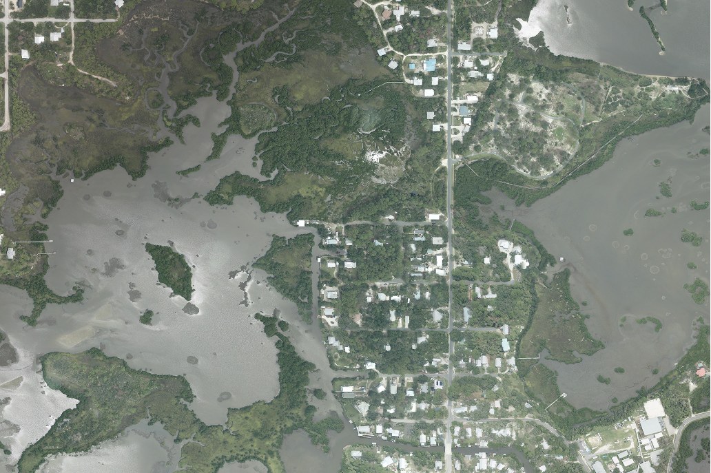
In Cedar Key, the route matters as much as the spot
Cedar Key is a place of low islands, muddy flats, oyster bars and winding tidal water. It is not a long, open surf beach. A successful fishing plan starts with knowing how you will reach the water and how you will get back when the tide changes.
Water can spread across a flat and make it look easy to cross. A few hours later, the same route may expose mud or shell. Do not follow a shallow shortcut simply because a smaller boat just used it. Your hull, motor and return time may be different.
The fishing rewards attention to small changes. An oyster edge beside a channel, a drain through marsh grass or a patch of deeper water can be more useful than a large area of featureless shallows.
For a first visit
Consider the city’s designated fishing pier. It lets you learn the local water without making a boat route your first challenge.
For a return visit
Build a short, tide-aware boat or kayak outing. Choose one launch and a nearby fishing area with a clear way home.
GETTING TO THE WATER
Separate the public pier from the boat launches
DOWNTOWN · SHORE FISHING
City of Cedar Key Fishing Pier
The city lists its public fishing pier at 550 Dock Street. This is the straightforward town option for someone arriving with a rod and a small bait bucket.
Pick a position that leaves room for other visitors. Start with a small shrimp bait and enough weight to fish the intended depth. If the line immediately swings under the pier, change the angle or location rather than feeding more line into the snag.
Storm damage and repair work can change pier access. The city’s current visitor page lists the town pier, but that should not be confused with every other structure around Cedar Key. Check signs at the actual entrance.
CITY MARINA · LAUNCH ACCESS
Cedar Key Marina
The city marina serves recreational boats and a working commercial fleet. Launch passes are required for the city’s boat-launch facilities. Sort out the pass and prepare your equipment before occupying a ramp lane.
Local clammers, crabbers and other commercial crews use this water for work. Give them room to maneuver and avoid parking tackle beside the launch. Ask where a kayak should unload if the main lane is busy.
Choose a route that matches the forecast and your craft. A marina launch does not make the surrounding shallow water simple to navigate.
MARSH WATERS · PADDLING
Cedar Key Scrub State Reserve waters
Florida State Parks describes fishing opportunities in the shallow creeks and salt marsh beside the reserve. It also states that there is no launch inside the reserve. Do not arrive expecting a water-access ramp at the trail entrance.
The park points paddlers toward the ramp at the FWC Senator George Kirkpatrick Marine Laboratory off State Road 24. Verify its current access before planning your trip. Use the ramp as a departure point, then keep clear of research facilities and posted areas.
For a kayak, choose a short stretch with room to turn around. Narrow creeks can be sheltered from waves but still leave you with a difficult return when water drains away.
OFFSHORE ISLANDS · WATERCRAFT REQUIRED
Cedar Keys National Wildlife Refuge
The refuge’s islands are reached by watercraft. The U.S. Fish and Wildlife Service describes shallow water, mudflats and oyster bars around them. This is habitat to understand carefully, not a list of islands to visit without checking restrictions.
Snake Key has an annual March 1 through June 30 closure covering its beaches and a 100-yard water buffer. The refuge describes Seahorse Key access during that period as conditional. Current signs and refuge notices are essential before approaching either island.
Fishing access does not mean every island interior is open for walking. Stay within permitted areas and give nesting or resting birds room.
Do not mix up the piers: A county notice in April 2025 reopened the No. 4 boat ramp after temporary repairs but kept its fishing pier closed. That notice is separate from the downtown city pier. Verify the current status of the exact place you intend to use.
YOUR MOST IMPORTANT PLANNING TOOL
Think about the lowest water you will meet
It is easy to judge a route from the water level at launch time. For Cedar Key, judge it again for the return. The shallowest part of the day may arrive while you are fishing.
Wind can move water across the coast and change what you see compared with a prediction. A marked channel also does not guarantee that a shortcut beside it has enough depth. Stay on a route you can identify and use safely.
As water drains off a flat, a creek can become the remaining travel lane. This is an explanation of marsh habitat, not a Cedar Key navigation chart.
Before the boat goes in
Check the predicted low water during the whole outing. Consider how far the route is from the launch and whether the wind will make the way back harder. Keep enough fuel or paddling energy for a longer return if your first route is unsuitable.
As water rises
Fish may gain access to food along shallow shell and grass edges. Approach without pushing a wake across the area. A bait placed along the edge can be more useful than driving directly over it to get closer.
As water falls
Small drains can carry food toward deeper channels. Work the outside of the drain while keeping your craft in enough depth. Do not follow feeding fish into a place where you could become stuck.
When the current eases
A pause in movement is a chance to inspect the rig and look at the next edge. Try a slower lure or a different depth. Avoid treating every quiet spell as a reason to run a long distance across unfamiliar flats.
WHY FISH USE SHELL AND MARSH
Learn what is living at the edge
Oyster bars are rough clusters of living shell and old shell. They create hiding places for small animals. Nearby marshes and soft bottom support more food, including crabs, shrimp and small fish.
That does not mean you should put every bait on top of the highest oyster pile. The outer edge, a small opening or a strip of deeper water may give a fish an easier place to feed and give you a better chance of retrieving the rig.
A fiddler crab at Cedar Key. Small crustaceans are part of the shoreline food supply. Photograph by Andrea Westmoreland, 2011. Attribution and license.
Fiddler crabs are easy to recognize when a male shows its enlarged claw. They can be useful sheepshead bait where using them is legal. Seeing them in a refuge or park does not authorize collecting them there. Buy bait or confirm the collection rules for the specific property.
Watch the marsh without trampling it. A quiet shoreline can reveal movement in the grass, a small wake or baitfish leaving a drain. Those are useful signs even if you cannot identify the larger fish making them.
LIKELY TARGETS
Choose the fish before choosing the rig
Redfish
Focus on shell edges, marsh margins and water deep enough for fish to travel between them. A live shrimp, small baitfish or a soft lure gives you several ways to test that route.
Position the boat outside the feeding area. Bring the offering along the edge rather than repeatedly landing it in the grass. Check the leader when it rubs shell.
Spotted seatrout
Look for open water beside grass or other bottom changes. A shrimp held above the bottom with a float can be easier to fish than a heavy sinker.
When using a jig, choose a weight that lets the lure swim instead of plowing. Work nearby deeper edges during colder periods and give the presentation more time.
Black drum
A small crustacean bait near bottom food can interest drum. Fish around a suitable edge where the bait remains visible instead of vanishing into thick mud or shell.
Keep pressure steady and choose gear that lets you control the fish near rough cover. A heavy fish on very light tackle can be difficult to land and release promptly.
Sheepshead
Hard structure and shell-bearing areas are worth attention. Offer a modest crab or shrimp bait close to the feeding surface.
Watch for a faint tap, a pause or an unexpected weight on the line. Inspect the hook after missed bites. An oversized bait can hide the point.
Flounder
Work sandy openings and lower edges where moving water carries food. A small baitfish or bottom-running soft lure is a useful approach.
Keep the lure near the bottom without dragging it into every oyster crevice. Species rules and harvest closures still apply when fish are present.
Spanish mackerel
In suitable warmer conditions, look for schools of small fish in more open water. A bright, compact spoon can cover the moving activity.
Do not rush a boat through the bait school. Cast toward its outside edge and protect the line from teeth with an appropriate leader.
The refuge also lists tarpon and sharks among local species. Those require a different level of tackle and handling preparation. They are not the best reason to turn a beginner’s short kayak trip into a long open-water chase.
FISHING AROUND ROUGH BOTTOM
Make the bait easy to find and the rig easy to recover
A float beside an oyster edge
Use the float to hold a shrimp above the roughest shell. Adjust the length beneath it as the depth changes. Let the bait drift across the outside lane rather than forcing it into the bar.
If the float lies flat, check whether the bait or weight is resting on bottom. If it drags constantly, the rig may be set too deep for that stretch.
A soft lure through an opening
Find an open strip before casting. Start the retrieve with enough speed to keep the hook out of the shell, then slow it where the bottom is cleaner. A weedless-style hook can help around vegetation, but it does not make a lure immune to oysters.
After a snag, inspect the line near the lure. Replace damaged leader before the next cast. A small repair now can save a fish later.
A bottom bait from the pier
Lower or cast to a position you can keep separate from other anglers. Use a small bait and maintain contact with the rig. If the current sweeps it beneath the deck, retrieve it before it becomes trapped.
With children, use fewer rods and a clear casting order. The quiet appearance of the town waterfront does not remove the need to watch where a hook will travel.
TACKLE FOR SHALLOW COASTAL WATER
Carry spares for abrasion, not just lost fish
Bring extra leader, several hooks and a few jig weights. Shell damage is a good reason to retie a knot even if the lure is still attached. Run your fingers carefully along the leader and feel for rough sections.
A medium spinning rod around seven feet is a practical starting point for many inshore methods. Choose the line strength for the fish and cover, then set the reel’s drag so the line can give under pressure. A locked drag does not solve a bad angle around shell.
Polarized glasses can reduce surface glare and help you notice bottom changes. They cannot show reliable depth through every patch of stained water. Use proper navigation information and your experience, not color alone.
For paddling, add a fitted life jacket, signaling equipment, drinking water and a dry way to carry communication equipment. Keep loose hooks out of the seating area. Secure the rod so a sudden movement does not put it under the boat.
HOW TO ADAPT YOUR VISIT
Four seasonal ways to approach Cedar Key
Cooler months
Expect a slower style of fishing and give deeper nearby water attention. Wind following a front can change the usable water level and make an exposed route less appealing.
A short pier session may be the better choice when a small-boat outing looks uncomfortable.
Spring
Explore warming edges and watch for more visible feeding activity. Keep the wildlife-refuge closure period in mind before choosing an island route.
Protected nesting areas are not optional stops, even if fish appear to be active nearby.
Summer
Plan a manageable early outing and leave enough time to avoid developing storms. Shallow water heats quickly, so consider nearby depth and moving water.
Live bait needs attention in hot weather. Keep the container shaded and properly aerated.
Fall
Look for food moving along the marsh and shell edges. A useful pattern can change as water cools, so keep notes rather than repeating the same route automatically.
Recheck the wind before crossing open water toward an island.
No season removes the need to check harvest rules. A useful month for finding a fish and a legal month for keeping it are separate questions.
A SMALL PLAN BEATS A LONG GUESS
Build the outing around one learning goal
Learn the town pier
Check access, bring shrimp and spend an hour comparing two depths. Watch how current changes the line angle. Leave with a useful observation even if the catch is small.
Learn one marsh edge
Use a legal launch and stay close to a known route. Fish one drain and the deeper water beside it. Turn back while the route still has comfortable depth.
Learn an island approach
Check refuge restrictions first. Use a craft and route suited to the conditions. Observe the island edge from permitted water and leave nesting birds undisturbed.
If the boat touches bottom
Stop trying to power across the flat. Spinning the propeller can damage habitat and dig the craft in farther. Assess the situation calmly and use a safe recovery plan. Do not step onto deep mud or sharp shell without understanding the footing.
The better solution begins before launch: avoid a route that depends on the tide staying high.
SHARE THE COAST WELL
Keep island visits within the refuge rules
Cedar Key’s birds and shallow habitats are part of what makes the fishing area special. Stay outside closure buffers, follow landing restrictions and never push through a group of resting birds to reach a casting angle.
Florida fishing-license and harvest requirements apply as well. Check them for the species you intend to keep. Refuge access guidance is not a substitute for those rules.
At the marina, leave ramps and loading space available for others. On the flats, protect seagrass and shell habitat from the hull, anchor and motor. Back at shore, dispose of line where it cannot reach wildlife.
CEDAR KEY QUESTIONS
What visitors often need to know
Is Cedar Key a surf-fishing destination?
Its fishing is more closely tied to shallow islands, marshes, channels and oyster habitat. Do not expect the long open surf beaches found on some other Florida coasts.
Can I visit the refuge islands on foot from town?
The refuge islands require watercraft access. Before approaching them, check current landing rules and seasonal wildlife restrictions.
Why should I check the return tide?
A route crossed at higher water may expose mud or shell later. Plan for the shallowest water during your outing rather than judging the whole day from launch conditions.
Is there a kayak launch inside Cedar Key Scrub State Reserve?
The state park’s information says there is no launch within the reserve. It identifies an outside ramp near the FWC marine laboratory as an access option. Verify that ramp before traveling.
Are the downtown pier and the No. 4 pier interchangeable?
No. They are separate places with separate access histories. A notice about the boat ramp does not necessarily mean its nearby fishing pier is open.
Can I gather fiddler crabs anywhere?
Collection rules depend on the property and protected area. Confirm permission before taking bait from a park or refuge.
What should I try if every cast catches shell?
Fish the outside edge, reduce the depth beneath a float or choose a cleaner opening. Continuing to cast into the same crevice usually produces more lost tackle.